Cyclone Road 
CHASE BLOG
Cyclone Road |
CHASE BLOG |
|
Blog Front Main Chase Page All Chase Reports YouTube Site Feed  
Amos Magliocco's Storm Chase Blog
|
Thursday, March 30, 2006
Posted
12:18 AM
by Amos Magliocco
A excellent chaser and forecaster jumps into the blogosphere, Jeff Snyder, a grad student at OU Met. I've added Jeff's link on the left. Wednesday, March 29, 2006
Posted
5:42 PM
by Amos Magliocco
Chasers spend a lot of time bickering over divisions, but there is none so dramatic as the difference between a chaser in the field and one stuck at home. I knew Eric was thinking about a hundred details and all the preparation required for a long-distance chase. His didn't say anything of the sort, but I knew there was no time to chat with someone who could only express regret at not going. So I wished him luck and trudged home. I've since looked over the data more carefully and agree with the emerging consensus that the best target is ahead of the dry punch in eastern parts of North Central Kansas and South Central Nebraska. This 12z NAM (and even 18z) restores the luster of prior runs with the chance for low-topped supercells ahead of the surface low. A wedge of instability develops under the approaching midlevel cold pool. Since the 18z ETA reduces CAPE values in North Texas (remember our midlevel warming?), the northern target is the best choice. I think storm motions in Central and Northern Oklahoma will make storms mostly unchaseable, otherwise that area could warrant more careful scrutiny. I won't rule out a storm here in Texas, but my enthusiasm is waning. In the medium range, the weekend and beyond looks promising. The moisture is building and looks like it's here to stay. Several veteran forecasters have expressed optimism that April could provide early returns for chasers in the central and southern plains.
Posted
9:31 AM
by Amos Magliocco
The northern target continues to drift north on the 12z NAM, now into the eastern sections of south central Nebraska. The parameters still look good for instability beneath the strong midlevel cooling and shear immediately east of the surface low. Last night's GFS held the surface low in Kansas much longer and deepened it well beyond the NAM's solutions. I think it would be lucky for those chasing the northern target to keep the low in Kansas. I'm always suspicious of returning instability that far north this early in the season, particularly with ongoing convection around southeast Texas which has already crippled recovery for today's setup along the dryline. If I had the day off tomorrow I would probably still choose the southern target because of the model inconsistency and potential for failed recovery north of Kansas. As it stands, I don't have that choice. I'll chase north Texas or southern Oklahoma tomorrow and hope the show isn't finished by the time I reach my vehicle. Tuesday, March 28, 2006
Posted
2:00 PM
by Amos Magliocco
However, Wednesday begins to offer more interest to chasers who can reach the Texas panhandle. The shear values are excellent, with steering currents normal to the dryline, and enough capping inversion that isolated cells are certainly what one should expect if convection develops in daylight hours. If I had the time, I'd ramble out to CDS and make this a two-day show. For Thursday, this morning's NAM depicted a weaker and more northeastern placement of the surface low, a slightly more neutral shortwave trough axis orientation, and all the disappointment that flows from that: weaker surface pressure fields, diffuse drylines, and reduced convergence along boundaries. It also could mitigate widespread early convection to some degree, particularly if the low deepens mostly later in the period. What would be helpful to chasers is a later arrival for the whole system but with the same negative tilt orientation. Too bad we can't pick and choose features from various model runs. What we have is a mildly-interesting triple point play in northern Kansas and also potential along the dryline from Oklahoma into North Texas. The cold core possibilities look less attractive than before because a progressive surface low reduces the size and instability of the "warm sector" that on earlier runs waited out ahead of the dryline punch. Further south into Oklahoma, midlevel speeds around the time of chaseable storms create motions over fifty knots. This does not make for a good time. Only in North Texas do you see a combination of supportive 0-6k shear values co-located with chaseable speeds per Bunkers of ~30 knots in the same areas as moderate instability and sufficient lift around an eastward mixing dryline. Problems with North Texas include subsidence from the wave passage and midlevel warming between 18z and 0z, raising the specter of 1998's "CAPE-robber" nightmares. I learned a long time ago to ruthlessly interrogate failure mechanisms in North Texas because, despite perceptions to the contrary, this is a lousy place for supercells and tornadoes and always has been. One or two good years in thirty is an anomaly, not a trend. When North Texas chasers want to see tornadoes, they find themselves on 287 or I-35. But...Thursday might be different. It's entirely possible that North Texas and Southern Oklahoma might be the best possible targets for at least the dryline portion of this setup. Yes that's convenient for me since I'm grounded until 2:00 PM, but it may also be the truth. We'll see what the next few runs deliver. Monday, March 27, 2006
Posted
1:05 PM
by Amos Magliocco
Wednesday and Thursday are of immediate interest, but the best looking chase on the GFS currently is Sunday in northwest Texas, where strong shear arrives into the season's first true "extreme" instability. A juiced boundary layer waits east of a tight dryline gradient with storm vectors normal to the boundary and chaseable motions. Unfortunately, Sunday might as well be in May for all the changes we're likely to witness in the forecast between now and then. But the weekend's solution for both Saturday and Sunday has looked good for three runs now. It's something to watch. I have found that a run of chases like this can tax early season preparations. Your inventory of blank tapes that looked sufficient for a one-day chase two weeks ago might not hold up between Wednesday and Sunday. Your camcorder batteries need recharging again probably. By the time you get home from chasing Thursday, how much time will you have to recycle your gear for departure Saturday morning? Less than you think. I'm going to do as much work as I can tonight and tomorrow despite knowing that I can't chase Wednesday (my hunch is that the system slows and makes Wednesday a nocturnal event) and will suffer limited range on Thursday because of my teaching schedule. But the weekend, once again, is wide open. It's nice to see April coming. Sunday, March 26, 2006
Posted
6:18 PM
by Amos Magliocco
Last night I watched a local documentary about a group of writers who launched a new literary magazine. Part of their motivation came from what they percieved as an unfair system for the solicitation and selection of material in contemporary journals. They wanted to do things differently, and open the range of aesthetics for a more inclusive project. Sounds great, right? Well, as everybody knows, the best way to foster a more egalitarian artistic environment is to obliterate "competing" formats, preferably by fire. About a quarter of the way through the documentary, the founders of the new magazine gathered around an open grill and burned copies of another local literary journal, setting the poems, stories, photographs, and reproduced paintings of other artists on fire. I assumed that creative writers (or anybody who loves books or literature) were more or less "on the same side" in so much as they agreed on the power or beauty of words and ideas, and saw books as important, sacred objects that merit protection. I was pretty sure I knew what kind of people burned books. Today I'm not so sure anymore. Thursday, March 23, 2006
Posted
7:45 PM
by Amos Magliocco
Of course we all know George Bush isn't from Texas, but Maines is, from Lubbock actually. It doesn't get more "Texas" than Lubbock, and Texas music has no name more famous than Maines. Lloyd Maines, that is, Natalie's father and the legendary steel guitar player, songwriter, and producer who appears repeatedly as either a player or producer for some of the genre's greatest artists and recordings. The scope and diversity of acts who have sought Maines' genius is remarkable. The list runs from Joe Ely to David Byrne (Talking Heads) and from James McMurty to Wilco and Uncle Tupelo, with Jerry Jeff Walker, Ray Wylie Hubbard, Pat Green, Cory Morrow, and Robert Earl Keen among dozens more. Essentially, there are no significant Texas Music acts who have not worked with Lloyd Maines. His daughter Natalie has earned fame and fortune with the popular Chicks, but has yet to approach her father's status as a artist of integrity and vision. This is about to change. I'm not a fan of the Dixie Chicks by nature. "New" country music sounds like recycled pop-rock from twenty years ago to me, back when I thought Dokken was doing something interesting. Mutt Lange and Shania Twain, for example, have sold a bazillion records to brain-dead dittoheads by regurgitating Def Leppard b-sides with distorted Telecasters and big choruses. I swear sometimes I think I hear Joe Elliot back there in those fat, loopy vocal tracks. Once upon a time, Lange produced metal's seminal record, AC/DC's Back In Black, but the Austrian born writer-producer underwent a lobotomy immediately after marrying the super-hot Twain. Now Mr. and Mrs. Lange create the sort of dreck radio-country fans adore: Hallmark love songs with clever turns of phrase and blatant right-wing political and religious propaganda. Can you imagine Merle Haggard or Waylon Jennings writing songs for the government? I knew eventually the Dixie Chicks would have to release new music. I assumed that Natalie Maines, pressured by friends, bandmates, and record executives, would appease the Wingnuts and perhaps swear loyalty to militant right-wing fascism or at least promise to be a good little liberal and shut her mouth. Instead, the first lyric from Taking The Long Way is the defiant anthem "Not Ready To Make Nice," in which Maines, Lubbock born and bred, tells the right wing jihadists to go fuck themselves. Well, not literally, but...wow: "I made my bed and I sleep like a baby This is an intriguing move for a writer emerging from the fan base of popular country music. A press release reveals more surprises. Producer Rick Rubin (Johnny Cash, Tom Petty) assembled a band that signals a bold seriousness of musical intent: Red Hot Chilli Peppers Drummer Chad Smith, Heartbreakers greats Mike Campbell and Benmont Tench, session legend Larry Knechtel, and songwriters Pete Yorn, Dan Wilson, and Gary Louris of the Jayhawks. What a lineup! You don't gather that crew of players and writers unless you plan to expand your music beyond formulaic, radio-friendly pop tunes. Taking The Long Way is due May 23rd and could be worth the wait. At the least it signals a turn against the political intimidation practiced by the right-wing, and, most importantly, emerging from a genre that they surely thought they had subjugated. Wednesday, March 22, 2006
Posted
9:46 AM
by Amos Magliocco
What's coming up for chasers? Who knows. GFS and EC advertise a few shortwaves over the next seven to ten days, with the second wave perhaps encountering some instability over the central and southern plains. The models performed badly in the evolution and placement of the warm sector last weekend, particularly in the two to three day range, and my confidence in their transitional season accuracy is appropriately reduced. Monday, March 20, 2006
Posted
10:08 AM
by Amos Magliocco
I learned pretty fast that David Chase, the series' creator and executive producer, was the worst writer on the roster. His episodes were clunky and boring, loaded with expositional dialogue, meandering plot lines, and entirely predictable conclusions. He wrote the most disastrous Sopranos episode of all time, the premiere of Season 3: a show focused on FBI efforts to plant a bug in a lamp. For me, the emblem of Chase's misunderstanding of his own show was a scene in an FBI lab, where a technician uses microscopic instrumentation to fashion a listening device. Hey David, this isn't fucking Adam 12. This show is about Tony Soprano and his two families. You could feel the other writers wincing at that sophomoric script, which they spent the next several episodes distancing themselves from until the lamp was unceremoniously removed from Tony's basement when Meadow went to college. In other words, it went nowhere. To his credit, Chase has co-written a few beauts, like the final show of Season 2, when Big Pussy winds up at the bottom of the ocean. That teleplay featured a brilliant dream sequence woven around Tony's severe food poisoning, and the shifting between dream and reality unveiled to Tony something he had "known" subconsciously, that Pussy was an informant for the FBI. The problem with David Chase is he goes back to the well too often. Last night, he interwove another dream sequence, this one occasioned by Tony's coma, and tried to suggest the exploration of a completely separate lifestyle for the boss of New Jersey. James Gandolfini even dropped his Tony-dialect and spoke as he does normally, which was the most interesting aspect of the storyline for me. But it just didn't come off. The other thread was Carmela's confessional vigil at Tony's ICU bedside and the inexplicable trouble AJ decides to cause. Ho-hum. This might have been written by any talented freshman in an Intro Creative Writing class. Did anything happen to complicate these characters? No. Lucky for us, Chase had the good sense to recognize his lack of story and lean on the acting genius of Edie Falco, giving her most of the teleplay's lines to do with whatever she could. She can do a lot, even with blocky, gratuitous dialogue laced with sentimentality. I don't know what the future holds for Sopranos. The roster of writers is changed from prior seasons. Robin Green and Mitchell Burgess, still listed as executive producers in the credits, signed a high-dollar development deal with NBC during the Sopranos layover. Let's all cross our fingers that they wrote some episodes for this season. Frank Renzulli is not listed. The actor who plays Christopher Moltananti, Michael Imperioli, has written a few good episodes through the years and Terrence Winter remains and has a history of fair work. Several other names are unfamiliar. You would think that these writers could do something with characters of such well-rendered complexity and in such compelling circumstances. Surely better choices are available than shooting them in the stomach with Alzheimer's lunatics (another absurd choice of Chase's: wasting Dominic Chianese by turning Uncle Junior into a doddering nutjob) and then dramatizing more crying jags at the bedside. Let's hope the choices in the next episode are more interesting. Sunday, March 19, 2006
My analysis this morning was not encouraging to me, with all the precip, high clouds, and retreating warm front this morning. I was hoping the 12z RUC could offer some glimmer of hope that our warm sector could at least threaten the Crane to SJT line (south of 20), but the new panels just in moments ago aren’t encouraging. It looks like a similar scenario to yesterday: too much precip and clouds. I do expect supercells but probably around sunset and south of SJT. That’s too far with school tomorrow and a nasty cold that seems to get a little worse every day. I wouldn’t give a shit about being sick if things looked good, but they don’t. They look very conditional and it’s March. I’m a no-go at this point unless somebody talks me into it in the next hour.
Posted
12:28 AM
by Amos Magliocco
Again, this isn't a case of a lack of sufficient instability; the problem is how far south will it be? I can't and won't drive down to Big Bend National Park, hire a boat across the river, and hike up to Boquillas Del Carmen for a glance at a storm tomorrow. It's March. I hope I'm wrong. Saturday, March 18, 2006
Posted
8:00 AM
by Amos Magliocco
But the convective instability can support supercells down where it is. Yesterday's impressive supercells around FST certainly caught the attention of snoozing Texas chasers like me who had long ago blown Friday off. I wouldn't be surprised to see something like those storms again today, perhaps around the same area. With some clearing and less interference from cold pools generated by northern convection, I see an area from Pecos to Crane to San Angelo where isolated rotating storms can break the cap in elevated helicities along the front where surface winds back. I'm not so confident about where the lift comes from, however. This isn't the setup I had hoped for, and with so much cool air, more on the way, extensive cloud cover (though there is some hope for drier midlevels upstream), and less than favorable chasing terrain nearer I-10, I'll sit this out and wait for tomorrow. I anticipate chasing tomorrow, maybe in the area I thought would hold promise today (along and near I-20), but I can't justify the long trip and overnight stay for today's action. Friday, March 17, 2006
Posted
1:45 PM
by Amos Magliocco
Posted
10:10 AM
by Amos Magliocco
Now the weather. Today I woke up with a full-blown cold and I was hoping the new ETA could buoy my spirits. But, as usual so far in 2006, my anticipation is deferred for another day. Saturday is off the board entirely, for the combination of low instability, distance, and my sudden illness. Sunday looked interesting for a few runs, but the ETA (our model du jour at the moment) continues the trend of slowing and deepening the main trough while delaying its shift to negative tilt until early Monday. This results in weakened surface features such as a diffuse dryline, reduced convergence values, and a weaker surface low. In addition, the model indicates extensive showers and storms should be ongoing at the start of the period, elevated convection in the upglide regime that could hamper the entire event, even into Monday. I'm impressed with the instability progged for Sunday given ongoing precip and high clouds courtesy of midlevel moisture. I won't rule out chasing Sunday, but the new model output isn't encouraging. Monday looks like the day for severe reports. However I'm not sure if this looks like a chase day, with tremendous forcing and a fast moving system barreling through North Texas. Timing will be critical. Until the model stops trending one way or the other, it's impossible to predict with confidence when anything will occur. As a friend of mine said last night, we could be chasing cold core on Tuesday at this rate. Wednesday, March 15, 2006
Posted
4:26 PM
by Amos Magliocco
Tuesday, March 14, 2006
Posted
12:03 PM
by Amos Magliocco
I'm always drawn to the "event before the event" during the early season, hoping for the unlikely, isolated supercell in weaker flow aloft (and prior to the Chaser Nation armada). This weekend might invite me into southwest or south central Texas for the preview chase, and with some short fiction progressing nicely, I won't resist. A bust in southwest Texas is no bust at all. I'll break out the laptop and find myself a rock perch to pound out another 1000 words. Monday, March 13, 2006
Posted
2:47 PM
by Amos Magliocco
I am so far behind on email now that the situation is nearly hopeless. I'll try to catch up by the end of the week. I might post another chase blog entry on Thursday or Friday. Wednesday, March 08, 2006
Posted
9:03 AM
by Amos Magliocco
I know six chasers spending the night in various locations around Kansas, anticipating today's event. I think they have a better chance to see something this afternoon and evening than I did yesterday. However I am surprised this morning that 12z soundings indicate continued trouble with the moisture return, and surface observations show an inconsistency to the moisture field horizontally as well. There are holes and drier pockets, one south of Austin this morning, for example, that are cause for concern. Gusty winds can enhance mixing. I assumed that another full day of return would remedy the problem. But apparently our trajectories are less than favorable or there is some issue with the integrity of flow off the Gulf. If I were making a chase decision today I might be hard-pressed to ignore targets further south, such as in south central Oklahoma or even northwest Texas, given moisture questions. I don't think the Kansas targets are bad, by any means, with a strong surface low to back winds and create favorable hodographs (not to mention boundaries from yesterday's convection), but I also expect storms to fire along the dryline perhaps as far south as Abilene. Chasers might have their pick today. I have to prepare for my guests and take care of other errands. So best of luck to everybody chasing. I'm looking forward to the pictures. Tuesday, March 07, 2006
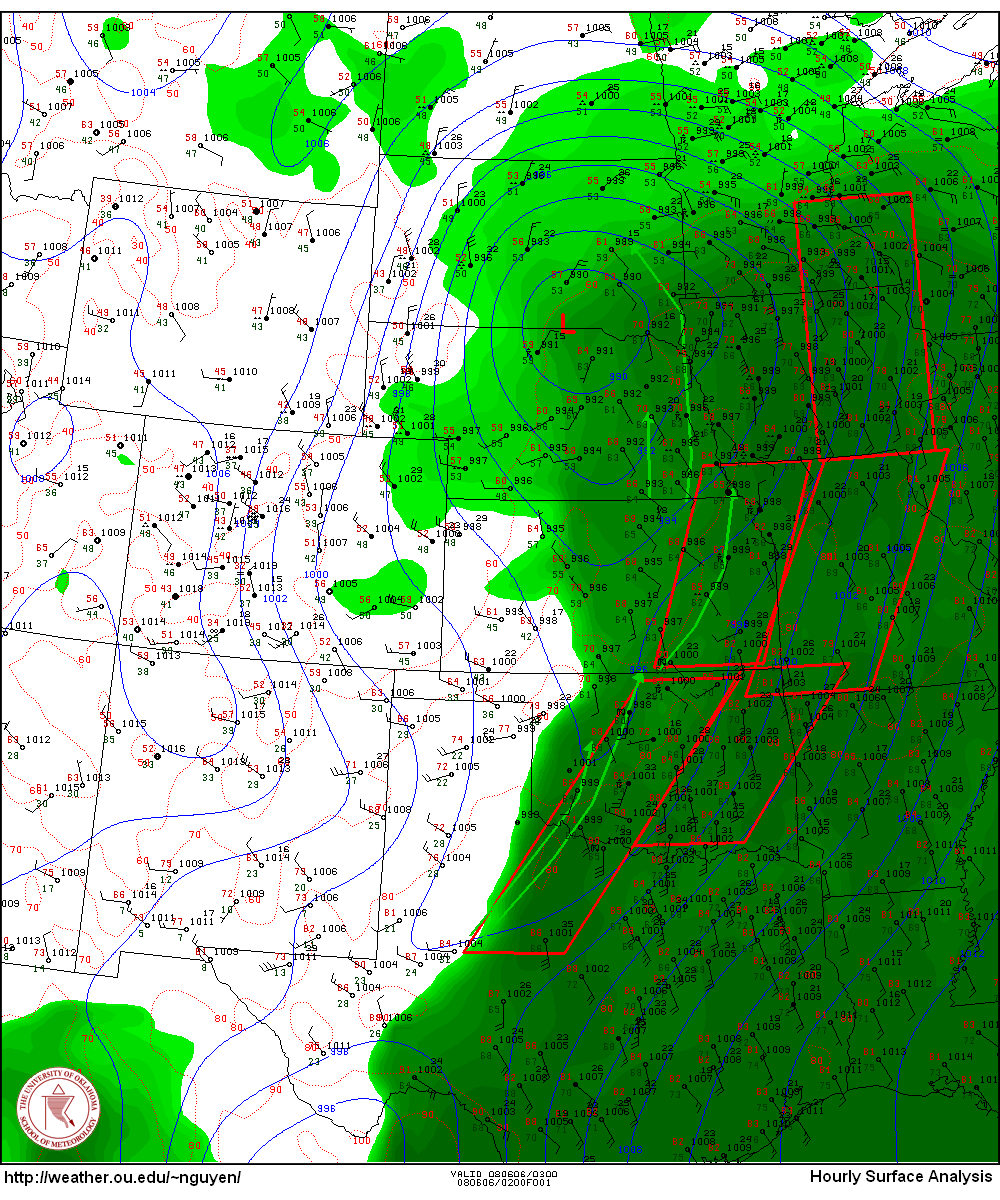
Under field of congesti in Paul's Valley, OK @ 22z. I think this is the best I'm going to see. Was thinking how unhappy I'd be to return home at midnight when I my confidence starting the chase was already so low. I'll wait here unless something compelling happens, then turn back for Denton around 0z.
Posted
9:48 AM
by Amos Magliocco
My target area is Enid to Watonga to Guthrie in north central Oklahoma. (Remember I can't leave until 2:00 PM and anything north of Enid is therefore out of range). Within that region, my forecast for initiation is 20%. Given initiation, my forecast for severe storms is 80% and, given severe storms, my tornado forecast is 5%. This makes it a highly conditional setup, but for the first chase of the year, why not? Here's what I posted on stormcasers.org:
Monday, March 06, 2006
Posted
11:12 PM
by Amos Magliocco
Also our ascent is into Missouri by 0z leaving the dryline under weak subsidence. At the surface we lack serious convergence along that same dryline that doesn't seem to want to move much. I suppose tonight's runs have pushed me back into the undecided category. That's the way it goes in March.
Posted
11:57 AM
by Amos Magliocco
Best way to find out what will happen tomorrow is go and see.
Posted
10:02 AM
by Amos Magliocco
Attention turns to Wednesday, which, because of the slower trough indicated this morning, becomes an I-35 corridor scenario with a dryline circulation sufficient for initiation, although the model omits precip along this boundary except up in southern and southeast Kansas. Other interesting developments are the slower speeds at 500mb in our area of interest, although Bunkers motions are still >35 knots at just north of due east for 0z Thursday. A little slower is ideal, but thirty-five knots isn't unchaseable. Wednesday's problems include a narrow ribbon of instability that storms may cross too quickly given those speeds and the potential for linear structure given veered 850mb winds. However, Wednesday looks like the better chase day right now. If I could chase I would focus on areas of northern to northeastern Oklahoma and southern to southeastern Kansas. I won't give up on Tuesday by any means. Capping inversions are the most difficult feature to forecast in any severe weather setup and no model can be trusted. I want to see Day 1 12z soundings before writing off the day as a cap bust. In the meantime, I'll prepare as if I'm chasing. EDIT: I'm not an "SPC chaser" and so I don't always check their forecasts before doing my own, but after posting the above note I looked at the Day 2 and discovered that they "amended" it a few hours after the first issuance and included areas of northwest Texas in the SEE TEXT. They added the following language: IN RESPONSE TO A WEAK SRN STREAM SHORT-WAVE FORECAST TO MOVE NEWD ACROSS THIS REGION...EXPECT ISOLATED STORMS TO DEVELOP ALONG DRYLINE WHERE CAP BECOMES LOCALLY BREACHED DURING THE LATE AFTERNOON. This doesn't change anything I mentioned earlier, especially since it was written before the 12z runs, but it's better than the absolute lack of any risk probability at all. Sunday, March 05, 2006
Posted
12:38 PM
by Amos Magliocco
Tuesday looks chaseable in several places: Kansas up by the surface low, or Oklahoma and Texas along the dryline, depending on focusing mechanisms or outflow boundaries from prior convection. I will only focus on targets south of Interstate 40 because I have to teach on Tuesday afternoon. If I don't talk about Kansas, it's not because I don't like it; it's because I don't have time to go up there. I don't have a target now anyway and won't begin thinking in those terms until Monday night. Let's see how our moisture return performs. Chasing seems very likely. Wednesday I have friends from out of state and chasing is out of the question. The rest of the week I'm in Austin, returning Sunday. In other news, Mike Peregrine wrote a fine essay on the subject of elitism in chasing and possible analogs for understanding some of the division and rancor. I think his comparisons are a useful way to examine the question. I posted a longer-than-intended reply in his comments section and want to direct people to Mike's work before they read my ideas; therefore I won't reprint my reply in this space. I will say, however, that I felt more clarity on the matter than before and hope the post will serve as my last word on the subject. I'm bored with it and chase season is upon us. Good luck to everybody. Saturday, March 04, 2006
Posted
1:16 AM
by Amos Magliocco
I'll say right off the bat that I think this series of waves will struggle with moisture unless the 850 mb winds back more than shown on the models. What 0z GFS depicts for several of the days is strongly veered 850s that scour moisture, resulting in diffuse drylines and shallow surface Tds. Gotta turn those winds around to south or south southeasterly if what they're bringing is bone dry air from the desert southwest, or otherwise this will be a series of overhyped squall lines. Next, I think it's helpful for chaser-forecasters to limit their vision during an event like this. If you try to forecast all these days at once, you won't do any of them well and you'll mix up the details from day to day and model run to model run. In a string of chases, I like to concentrate on "the storm in front of me," meaning the next potential chase day. Admittedly it may be necessary to scan the GFS or EC to make personal arrangements, but details of the event are rich enough that each day is a massive project by itself. "Sufficient unto the day is the evil thereof" is a good motto for chasers trying to keep their heads in an active week. And since you know what happens Tuesday will dramatically impact Wednesday, Thursday and Friday might as well be on another planet. I have seen many chasers miss events the next day because the shiny progs for 72 hours away distracted them. The chase in front of us now is Tuesday, and the NAM 84 hour panels show Tuesday morning, with the GFS covering the rest of the day. What I see Tuesday is a small incursion of Spring into the Kingdom of Winter, with lots of cold air on either side of the warm sector. Look at the 850 theta-e charts for Tuesday morning, afternoon, and evening. The warm sector barely maintains defintion. Will the moisture hold out? I suspect it might in Texas, hopefully close to I-35, but I don't have much hope for any place north of the Red River. South Central Oklahoma could offer some potential if moisture advection is stronger than advertised and low level wind fields remain backed. My target for the moment would be just south of the DFW area although it is not on the favorable quad of the upper level jet. But that jet max could be a figment of the model's imagination. My top priority Tuesday, a day I *can* chase, is to remain in the deep moisture. Friday, March 03, 2006
Posted
12:07 PM
by Amos Magliocco
Right now, as of this morning's GFS, the best day looks like Tuesday, strangely enough. And as I type that I realized that I actually *can* chase on Tuesday. Hmm. So perhaps some wishcasting on my part. But it's the only day where moisture looks strong east of the dryline in chaseable areas. On Wednesday, the warm sector shifts to northeast, east, and southeast Texas and Arkansas, although North Texas could be in the mix again at peak heating. My suspicion is that this wave is going to move through rapidly, since each run shows it smaller and smaller. This offers less time to advect moisture from the Gulf of Mexico. For Thursday, which is the exciting day for people who are two model runs behind, moisture is scoured by a Pacific front all the way to Alabama. Yes a surface low redevelops in the plains, but there's no moisture for severe storms, at least per this morning's GFS. This is all tentative and far away but the trend is for a smaller, faster wave coming through sooner than expected, whenever that might be. Thursday, March 02, 2006
Posted
4:42 PM
by Amos Magliocco
We have a visiting writer on campus over the next few days, Bill Roorbach, a writer I think many chasers might enjoy. Roorbach writes about the outdoors, about creating things with your hands, and in general about experiencing life as more than a series of fluorescent spaces with air conditioning and broadband. He's seen success in several genres, fiction and nonfiction. I'm looking forward to meeting the guy. His new book, Temple Stream: A Rural Odyssey, sounds very promising. Here's a snippet from the LA Times review (try to ignore the unfortunate label "Nature Writer"): "Following seasonal milestones -- the summer solstice, autumnal equinox, winter solstice and vernal equinox -- as well as his own ravenous curiosity, nature writer Bill Roorbach introduces readers to his beloved Temple Stream, a small, seemingly insignificant waterway in rural Maine near Farmington. Adjacent to his cabin, the Temple accommodates industrious beavers, slick frogs, countless birds, scores of fish and muskrats. Its shores harbor minks, poplars, wildflowers, coyotes, foxes and an odd assortment of humans, including Earl Pomeroy, a giant of a man with a grudge against outsiders. Roorbach focuses on the wonders of this particular stream, crafting haiku from the simplest scenes. For example, after a temporary thaw has refrozen the stream's surface, he writes: "You hesitate -- it's like walking on stained glass -- the sound is vandal-loud in the streambed silence." Entering Roorbach's attentive world, we can't help but witness the natural marvels that surround us -- humans and all. 
Posted
8:54 AM
by Amos Magliocco
Another large system is forecast to move through the plains during the middle of next week. I can't chase this one as I have friends coming from out of town and we're headed to Austin for a convention. I'm sure that while I'm gone, one of the great March outbreaks in history will unfold. Wednesday, March 01, 2006
Posted
11:04 PM
by Amos Magliocco
A few of these members were among those who screamed loudest at the proposal to add private membership on the Stormtrack website last summer. The drama never ends in chasing.
Posted
9:17 AM
by Amos Magliocco
Another note. I want to try probability forecasting on the blog this season because I believe that probabilities are the best way for a forecaster to convey relative confidence or lack thereof. Forecasting doesn't have to be a binary solution set: yes or no. You could do it that way, and many times people take the information that way no matter what, but that's far less information than expressing expectations in percentages. I have used probabilities in my personal chase decisions for years and feel comfortable with this style. The Storm Prediction Center has an excellent page on probability forecasting and explains how their methodology evolved. I recommend it highly and this is precisely the scheme I'll employ. For example, let's say this morning's NAM output verifies exactly come Saturday. Of course there's so much more data to examine Day 1 than what the model shows 84 hours out---like all surface features and what we'd find on soundings, etc---but for the purposes of this exercise, put those aside. If it verified exactly, I might say that the chance for isolated, chaseable supercells within 25 miles of any point within my specified area is 10%. Then I might say that given isolated, chaseable supercells (I'll try to define that later but I'm running out of time this morning), the chance for visible tornadoes within 25 miles of any point in the area is 20%. On first glance, that sounds like I'm saying there's a 20% chance for tornadoes, but that's not the case. I'm actually forecasting a 2% chance for tornadoes in that scenario, because you have to multiply .10 by .20 as the second value is dependent upon the first. If I'm forecasting a 2% chance of tornadoes that means that I believe there's a 98% chance that visible tornadoes will not appear within 25 miles of any point in the given area. Chasers deal with yet another layer of uncertainty: will we happen to SEE this tornado? Will we have the right angle or even the right storm? There's a probability involved in these questions as well, and if you factor it into our calculations above, you see why almost any chase is a relatively low-percentage affair. Time to go.
Posted
12:47 AM
by Amos Magliocco
The big trough that kicked off this round of model-gazing has all but fallen from the board, appearing now as little more than a small shortwave trough separating from the main system out west and riding the back of the mid-CONUS upper level ridge. So all the dynamical forcing and bombing surface lows that caused chaser coffin doors to swing open is gone now. The big trough is parked off the left coast a while, probably coming ashore with historical outbreak consequences while I'm in Austin. I don't know if I'll go or not. I'm headed to Austin late next week for a four day convention and could use the time more productively catching up on work. If there's a small chance, however, a drive out west sounds fun. Too tired to say much coherently.
|