Cyclone Road 
CHASE BLOG
Cyclone Road |
CHASE BLOG |
|
Blog Front Main Chase Page All Chase Reports YouTube Site Feed  
Amos Magliocco's Storm Chase Blog
|
Saturday, July 26, 2014
Posted
12:17 PM
by Amos Magliocco
    
Posted
11:55 AM
by Amos Magliocco
   Monday, July 21, 2014
Posted
10:20 PM
by Amos Magliocco
 Saturday, May 10, 2014
Posted
4:03 PM
by Amos Magliocco
 
Posted
3:48 PM
by Amos Magliocco

Posted
3:16 PM
by Amos Magliocco
 
Posted
2:48 PM
by Amos Magliocco
  
Posted
2:36 PM
by Amos Magliocco
     Sunday, May 12, 2013
Posted
10:10 AM
by Amos Magliocco
Chase Day 8 MAY 2013Hoped to stay in Texas for this one, but dewpoint spreads drove me to Altus and then Mangum, Oklahoma and finally west into the eastern Texas Panhandle to this storm, south of Memphis. Later shot the backside of a storm farther south, around Snyder. 
Posted
10:03 AM
by Amos Magliocco
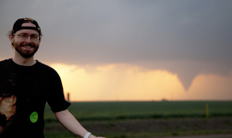
Chase day 15 APRIL 2013I left from school without any gear but the iPhone, drove west and caught this storm somewhere near Throckmorten maybe. I don't know. I don't feel compelled to research these chase accounts so exhaustively anymore when it's a low end event. This was very low end. The photo below looks like the storm is producing a tornado, but it's not. That's scud, driven by outflow. Saturday, May 11, 2013
Posted
10:29 PM
by Amos Magliocco
Chase day 30 MAY 2012: North TexasWhat I remember about this was playing around with highest possible ISO settings on the new camera, more or less after sunset. The Mark ii still rendered some color. 
Posted
9:14 PM
by Amos Magliocco
Chase day 27 MAY 2012In late May some friends came to the plains and we drove around in search of better storms. With Jason Foster, Ian Livingston, and Mark Ellinwood, I intercepted this storm along the cold front on 27 May 2012. In this image, Ian and Jason are in the foreground.
Posted
8:44 PM
by Amos Magliocco
Chase day 14 APRIL 2012April 14th was a big day with people chasing all over the place. This is the best image I captured that day, a funnel that was fully extended seconds before, but I was driving fast. That's my primary memory of that day, driving fast all over the place. This image and the next serve only to prove I did in fact participate in storm chasing activities, albeit poorly. 
Posted
8:27 PM
by Amos Magliocco
Chase day 13 APRIL 2012I chased April 13th and 14th somehow, somewhere, probably nearby on the first day and then in Oklahoma on the "big day," which was, for me, a big disappointment. Here's a few from the 13th (the day before the day):  Tuesday, March 20, 2012
Posted
11:47 AM
by Amos Magliocco
 Scott Currens, Bob Fritchie and I converged on the Shamrock, Texas Taco Bell, and tried the Doritos Locos Tacos while monitoring radar on our phones. When it was clear our target area had mixed out via an elevated dryline, we drove south and intercepted what we'd called the "Childress storm" three miles southeast of Hollis, Oklahoma a few miles north of the Red River. The storm intensified as we approached, but in person looked initially high-based and benign. It looked like an outflow dominant cell struggling with the high dewpoint depressions of its environment, a ragged updraft region and weak convergence. But soon, the first serious wall cloud emerged, and an impressive tail cloud formed as scud collected around a circulation before it crossed our N/S county road. We pursued the storm into Hollis and turned north on 30. Near the airport, we observed the second of many occlusions, this time with more promising signs of tornadogenesis, but the pristine green fields and lack of power poles or wires was too ideal a foreground, I guess. At McKnight, we made the fateful turn east on E1550, a perfectly fine and well-paved road but without any northern options that didn't terminate at the river. We were stuck driving east. We fell behind, but in doing so we noticed the incredible structure of the supercell. The farther we went, the better it looked.  Taken about 10 miles east of McKnight This was quite a sight, a seemingly low-topped cell with the stable-layer, polished sheen on deeply grooved stacks. Though we were well to the south and east, far out of position for tornado-viewing, we didn't mind. As Scott Currens said later, "Being stuck on that eastbound road was the best thing that happened." At that point I considered the tornado potential marginal at best--not the last wrong analysis of this persistent little storm. But when it reached the higher theta-e air in southwestern Oklahoma, and the more supportive shear arrived, the show was about to begin. During the last few miles of our journey to SR 34, the rotational signature on radar increased sharply and a wall cloud emerged in the distance. This was a large, dark blocky wall cloud, the kind that produce tornadoes you can't see when you're more than five miles away. We were probably ten to twelve miles south at this point. Finally we turned north on 34. Somewhere along the way we may have seen the first tornado near Reed, but I wasn't able to shoot it. We were parked near the fork of 283 and 34, one mile north of Willow, when the elephant trunk tornado descended.  Taken 1m north of Willow, Oklahoma, 0030z  This funnel dissipated but the same circulation produced another fully condensed funnel seven to ten minutes later.  Taken three miles north of Willow about 0038z. A great March chase with Bob and Scott, a reasonable distance traveled and an unforgettable storm. While it wasn't my first chase of the year (An extended reconnaissance to Lubbock two days earlier isn't worth writing about) it was a gratifying start to the season's opening schedule. Friday, November 11, 2011
Posted
7:40 PM
by Amos Magliocco
The red circles indicate major stopping points, of which there are too many. I couldn't quit shooting the Frederick-Tipton tornado (Tornado #1 on the map) because it was doing so many cool things: changing shapes, orientations, and posing behind some very cool foregrounds. Over and over I told myself I'd crop the shots, since I was pretty far away at the beginning. It's always a struggle to choose whether to keep shooting, since the tornado could dissipate any moment, or put the camera down for five minutes and blast west (blast being a relative term on the muddy Oklahoma backroads) another three miles to get closer. As it is, if I'd gone farther west in the beginning, I wouldn't have found myself directly between both the dying Tipton cone and the rapidly forming soon-to-be Manitou tornado. (Tornado #2 on the map). I eventually caught up fully to the Manitou-nado, meeting it at its dissipation point over Highway 183. 
|


